Where are the people we are concerned about?
Where are the people we are concerned about?

Credit: ©iStock/DonNichols
There is pronounced regional variation in the distribution of households experiencing fuel poverty. The West Midlands has the highest proportion of its households living in fuel poverty (around 13.8%), while the South East has the lowest proportion (around 8.2%). The regions with the greatest proportion of all of England's fuel poor households are the West Midlands and the North West. The North West also experiences the greatest fuel poverty gap (Table 3.1). Southern regions tend to have average annual temperatures approximately 2⁰C higher than in the Midlands and Northern England according to the Met Office, which is one reason fuel poverty is higher in the Midlands and North. Those regions with larger populations naturally tend to have a higher proportion of all of England’s fuel poor households.
|
Region |
% of households in fuel poverty in the region |
% of all fuel poor households in England |
Aggregate fuel poverty gap in the region (£m) |
Average fuel poverty gap per fuel poor household (£) |
|
East England |
9.0% |
9.3% |
95 |
436 |
|
East Midlands |
10.0% |
8.6% |
81 |
401 |
|
London |
10.0% |
13.9% |
99 |
304 |
|
North East |
12.0% |
5.8% |
34 |
255 |
|
North West |
11.0% |
14.3% |
104 |
312 |
|
South East |
8.0% |
12.7% |
117 |
395 |
|
South West |
12.0% |
11.7% |
123 |
447 |
|
West Midlands |
14.0% |
13.6% |
137 |
427 |
|
Yorkshire and the Humber |
11.0% |
10.2% |
86 |
359 |
|
All |
10.0% |
100.0% |
877 |
374 |
Table 3.1: Regional distribution of fuel poverty in England, LIHC definition, 2012 (DECC, 2014)1
The levels of fuel poverty within an English local authority and changing trends over time (based on the 10% definition) can be seen in the Department for Energy and Climate Change (DECC) online maps. For more detailed information about fuel poverty at the neighbourhood level in England, see the map tool which provides maps at the local authority and Census lower super output area level.
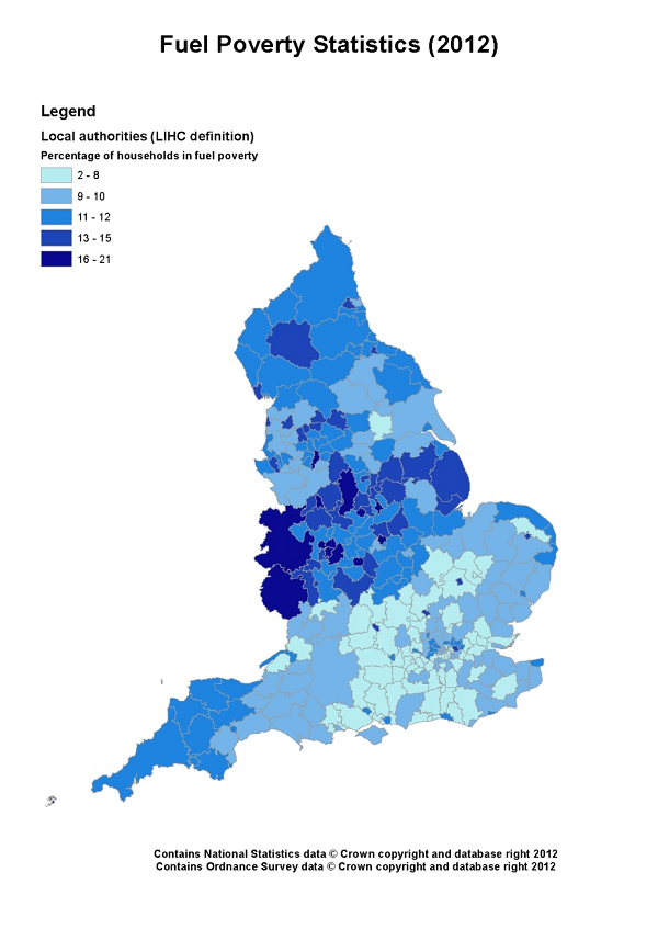
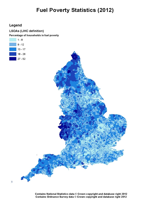
Mapping fuel poverty by local authority and census lower super output area in 2012 shows considerable variation in rates across England (LIHC definition). See Figure 3.1 and Figure 3.2 (the legend categories are based on where there are natural breaks in the data). There is variation throughout England but in very general terms, at local authority level there are particular concentrations of fuel poverty in local authorities in the Midlands and North and, to a lesser extent, the South West. When looking at census lower super output area level, those areas of higher fuel poverty are still visible, although the picture is more varied, and an area of very high fuel poverty stands out at the border with Wales, with pockets of high fuel poverty across the South West.

Figure 3.1: Percentage of households in fuel poverty in each local authority in England, LIHC definition (based on county/unitary councils)2

Figure 3.2: Percentage of households in fuel poverty in each LSOA in England, LIHC definition3
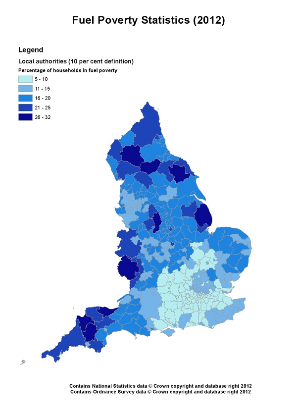
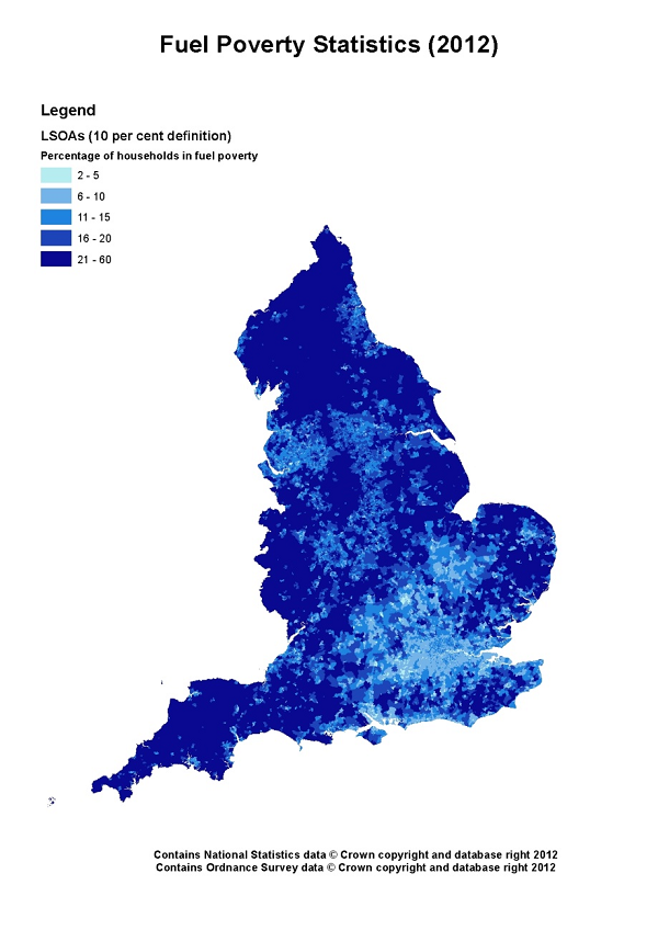
Mapping fuel poverty by local authority and census lower super output area in 2012 using the old 10% definition, also shows considerable variation in rates across England. See Figure 3.3 and Figure 3.4 (the legend categories are based on where there are natural breaks in the data). Note that the LIHC and 10% maps should not be directly compared as the legend categories are different. For the 10% definition, the most obvious difference is that the South East, London and parts of the East of England generally show lower levels of fuel poverty than the rest of the country. This is largely due to the difference in the way housing costs are taken into account in the two different indicators.

Figure 3.3: Percentage of households in fuel poverty in each local authority in England, 10% definition (based on county/unitary councils)4

Figure 3.4: Percentage of households in fuel poverty in each LSOA in England, 10% definition5
Fuel poverty tends to affect a higher proportion of rural than urban households and the average fuel poverty gap is higher in rural locations. Table 3.2 shows fuel poverty by extent of rurality in 2012, using the LIHC definition. Rural areas are also more likely to have colder temperatures than urban areas, due to the Urban Heat Island effect, which leads to higher temperatures around densely populated urban areas (see the section on Adapting Buildings). For information about types of households affected by fuel poverty see Section 1: Who is affected by fuel poverty? Despite the fact that the majority of the fuel poor live in urban areas (this reflects the higher urban populations and high cost of living in many urban areas, especially in the south east), the needs of the rural fuel poor should not be overlooked.
|
Rurality |
% of households in this group that are in fuel poverty |
% of all fuel poor households that are in this group |
Average fuel poverty gap (£) |
|
Urban |
10 |
79% |
£304 |
|
Rural - town and fringe |
8 |
8% |
£346 |
|
Rural - villages, hamlets and isolated dwellings |
14 |
13% |
£820 |
Table 3.2: Fuel poverty by rurality, LIHC definition 2012 (DECC, 2014)6
The depth of fuel poverty in rural households is much greater than in urban areas. The average fuel poverty gap for the most rural households (villages, hamlets and isolated dwellings) is £820 compared to £304 for urban households.7
Being off the gas grid drives high costs, with an average fuel poverty gap of £780 for households living in such dwellings (table 3.3).8 While 13% of English households are off gas, nearly 19% of fuel poor households in England are off gas. Households living in properties that are both off the gas grid and in rural areas face some of the highest fuel poverty gaps of all.9
|
Gas grid connection |
% of all households |
% of households in this group that are in fuel poverty |
% of all fuel poor households that are in this group |
Average fuel poverty gap (£) |
|
On gas grid |
87% |
10% |
81% |
£315 |
|
Not on gas grid |
13% |
15% |
19% |
£629 |
Table 3.3: Fuel poverty by gas grid availability, LIHC definition 2012 (derived from DECC, 2014)10
References
- DECC (2014) Fuel poverty detailed tables 2012. Detailed tables under the low income high costs indicator.
- Based on data from DECC (2014) Fuel Poverty Sub-Regional Statistics for 2012.
- Based on data from DECC (2014) Fuel Poverty Sub-Regional Statistics for 2012.
- Based on data from DECC (2014) Fuel Poverty Sub-Regional Statistics for 2012.
- Based on data from DECC (2014) Fuel Poverty Sub-Regional Statistics for 2012.
- DECC (2014) Fuel poverty detailed tables 2012. Detailed tables under the low income high costs indicator.
- Hills J. (2012) Getting the measure of fuel poverty. CASE report 72. Centre for Analysis of Social Exclusion for Department of Energy and Climate Change (DECC).
- Derived from DECC (2014) Fuel poverty detailed tables 2012. Detailed tables under the low income high costs indicator.
- Hills J. (2012) Getting the measure of fuel poverty. CASE report 72. Centre for Analysis of Social Exclusion for Department of Energy and Climate Change (DECC).
- DECC (2014) Fuel poverty detailed tables 2012. Detailed tables under the low income high costs indicator.

Built by:

© 2014 - Climate Just
Contact us
